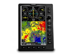
GPSMAP695是Garmin的极致便携的MFD。GPSMAP695配备了大屏幕和详细的电子海图以及对XM的兼容性,对角线高清晰度显示屏刻在日光环境下清晰阅读。
Physical & Performance:
Unit dimensions, WxHxD: 5.7"W x 7.7"H x 2.0"D (14.5 x 19.5 x 5.1 cm)
Display size, WxH: 3.6"W x 6.0"H (9.1 x 15.2 cm); 7.0" diag (17.78 cm)
Display resolution, WxH: 480 x 800 pixels
Display type: bright, color WVGA TFT with adjustable backlighting
Weight: 35.7 ounces (1012 g) with battery pack; 22.4 ounces (635 g) without battery pack; 12.7 ounces (361 g) RAM mount
Battery: rechargeable, replaceable Nickel-metal Hydride
Battery life: up to 3 hours with full backlight
Waterproof: no
Voltage range: 11-40
SBAS/WAAS receiver: high-sensitivity with WAAS position accuracy
IFR or VFR: VFR
Maps, Databases & Memory:
basemap: yes
Navigation database (includes Jeppesen® data): yes
Types of Jeppesen data: full and ARTCC, FSS frequencies and final approach waypoints
Navigation database coverage areas: Americas or Atlantic or Pacific
Preloaded Terrain database: yes
Preloaded Obstacle database: yes (U.S. and Europe only)
Preloaded SafeTaxi?airport diagrams: yes (U.S. only)
Preloaded AOPA Airport Directory: yes (U.S. only)
Preloaded Garmin FliteCharts®: yes (U.S. only)
Preloaded low & high altitude enroute airways: yes
Preloaded private airports: yes (U.S. only)
Preloaded street maps: no
Ability to add maps: yes
Accepts data cards: yes (SD cards)
Built-in memory: internal solid state
Waypoints/favorites/locations: 3,000
Routes: 50
Features & Benefits:
Moving map: yes
Patented panel page: yes
HSI (GPS-based): yes
IFR map mode: yes
Traffic Information Services (TIS) alerts compatible: yes
Audible terrain alerts: yes
Terrain resolution: standard
Smart Airspace Feature (generates and displays altitude-sensitive alerts): yes
Automatic logbook: yes
Separate serial and USB interfaces: yes
Voice prompts (e.g. "Turn right in 500 ft."): no
Speaks street names (e.g. "Turn right ON ELM STREET in 500 ft."): no
Lane assist (guides to proper lane for navigation): no
3-D map view: no
Bluetooth® wireless technology: no
Speed limit indicator (displays speed limit for most major roads in the U.S. and Europe): no
Traffic compatible (routes around traffic with a receiver and subscription): no
Custom POIs (ability to add additional points of interest): no
XM WX Weather & Radio for U.S. & Canada compatible: no
GPSMAP695

装备详情商家联系电话:010-58275000
厂商资料

厂商动态
- 行业率先获证,高新投三江独立式烟感通过国家最新强制性认证
- 浙江建英:深耕工业通风安全 全系非电气防爆通风部件重磅问世,助力夯实高危场景本质安全保障
- 国家级算力地标,高新投三江助力中金数据打造算力中心安全标杆
- 机器人时代:地震预警从"听见"到"做到"
- 高新投三江石油化工消防解决方案斩获a&s Top解决方案大奖
- 顺丰核心枢纽的安全密码,高新投三江为鄂州花湖机场筑牢消防防线
- 春暖花开,医路平安,高新投三江医院消防解决方案给出安全路径
- 复工复产进行时,高新投三江助力新能源产业安全生产开门红
- 高新投三江医药行业消防解决方案,筑牢健康产业安全防线
- 轻装上阵,猎翼绘形 | 冰柏科技“猎翼”单兵无人机建图识别系统发布